
Thank you for supporting this site ❤️
Make a donation
Make a donation
Springettsbury Township topographic map
Click on the map to display elevation.
Thank you for supporting this site ❤️
Make a donation
Make a donation
About this map
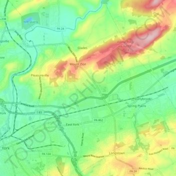
Name: Springettsbury Township topographic map, elevation, terrain.
Average elevation: 159 m
Minimum elevation: 73 m
Maximum elevation: 314 m
Thank you for supporting this site ❤️
Make a donation
Make a donation
Other topographic maps
Click on a map to view its topography, its elevation and its terrain.
Airville
United States > Pennsylvania > York County > Lower Chanceford Township > Airville
Average elevation: 209 m
Remeos Mobile Home Park
United States > Pennsylvania > York County > Fairview Township
Average elevation: 133 m
Thank you for supporting this site ❤️
Make a donation
Make a donation