
Thank you for supporting this site ❤️
Make a donation
Make a donation
Sand am Main topographic map
Click on the map to display elevation.
Thank you for supporting this site ❤️
Make a donation
Make a donation
About this map
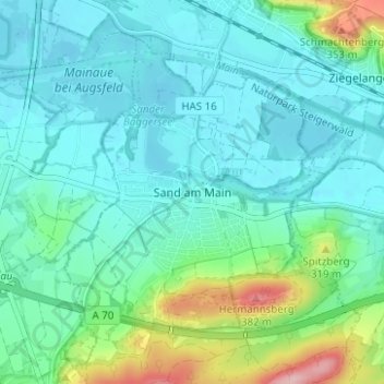
Name: Sand am Main topographic map, elevation, terrain.
Average elevation: 253 m
Minimum elevation: 217 m
Maximum elevation: 394 m
Thank you for supporting this site ❤️
Make a donation
Make a donation
Other topographic maps
Click on a map to view its topography, its elevation and its terrain.
97522
Deutschland > Bayern > Landkreis Haßberge > Sand a. Main > Sand am Main
Average elevation: 283 m