
Make a donation
Las Vegas topographic map
Click on the map to display elevation.
Make a donation
Las Vegas
In 1829, Mexican trader and explorer Antonio Armijo led a group consisting of 60 men and 100 mules along the Old Spanish Trail from modern day New Mexico to California. Along the way, the group stopped in what would become Las Vegas and noted its natural water sources, now referred to as the Las Vegas Springs, which supported extensive vegetation such as grasses and mesquite trees. The springs were a significant natural feature in the valley, with streams that supported a meadow ecosystem. This region served as the winter residence for the Southern Paiute people, who utilized the area's resources before moving to higher elevations during the summer months. The Spanish "las vegas" or "the meadows" (more precisely, lower land near a river) in English, was applied to describe the fertile lowlands near the springs. Over time, the name began to refer to the populated settlement.
Make a donation
About this map
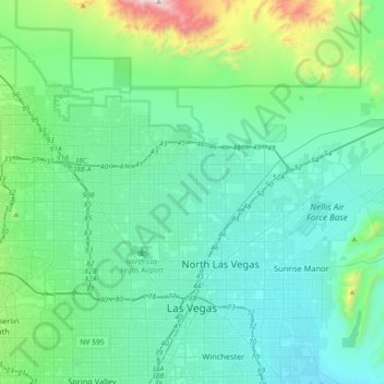
Name: Las Vegas topographic map, elevation, terrain.
Location: Las Vegas, Clark County, Nevada, United States (36.12955 -115.40658 36.40148 -115.06207)
Average elevation: 767 m
Minimum elevation: 514 m
Maximum elevation: 2,101 m
Make a donation
Other topographic maps
Click on a map to view its topography, its elevation and its terrain.
Highland Range Crucial Bighorn Habitat Area
United States > Nevada > Clark County
Average elevation: 917 m
Make a donation
Make a donation
Craig Ranch Regional Park
United States > Nevada > Clark County > North Las Vegas
Average elevation: 626 m
Make a donation
Mount Charleston
United States > Nevada > Clark County
The town of Mount Charleston is named for nearby Mount Charleston whose Charleston Peak at 11,916 feet (3,632 m) is the highest point in Clark County. The town of Mount Charleston is in a valley of the Spring Mountains to the northwest of Las Vegas, noted for its hiking trails. It is also known for its Retreat…
Average elevation: 2,594 m
Spring Mountain Ranch State Park
United States > Nevada > Clark County
"Because of the higher elevation, the ranch offers a diverse opportunity for plant study. Four plant communities are represented: Desert Scrub, Black brush, Pinon-Juniper, and Riparian. Plants typical of the desert as well as woodland can be seen, and with adequate rainfall the spring brings a burst of…
Average elevation: 1,188 m
Make a donation
Make a donation
Mount Charleston
United States > Nevada > Clark County
The town of Mount Charleston is named for nearby Mount Charleston whose Charleston Peak at 11,916 feet (3,632 m) is the highest point in Clark County. The town of Mount Charleston is in a valley of the Spring Mountains to the northwest of Las Vegas, noted for its hiking trails. It is also known for its Retreat…
Average elevation: 2,594 m
Blue Diamond
United States > Nevada > Clark County
Blue Diamond is the site of Cottonwood Spring (formerly known as Ojo de Cayetana, or Pearl Spring), a watering place and campsite on the Old Spanish Trail and the later Mormon Road between Mountain Springs and Las Vegas Springs. The springs are located on a mountainside south of the town at 36°02′44″N…
Average elevation: 1,106 m
Make a donation
Make a donation
Mount Charleston
United States > Nevada > Clark County
The town of Mount Charleston is named for nearby Mount Charleston whose Charleston Peak at 11,916 feet (3,632 m) is the highest point in Clark County. The town of Mount Charleston is in a valley of the Spring Mountains to the northwest of Las Vegas, noted for its hiking trails. It is also known for its Retreat…
Average elevation: 2,594 m
Make a donation