
Make a donation
Tengchong City topographic map
Click on the map to display elevation.
Make a donation
Tengchong City
Situated at the southwestern end of the (transversely faulted) Hengduan Mountains, Tengchong topographically assumes the form of a horseshoe with the opening facing the south. The easternmost sources of the Irrawaddy River issue from the high mountains at the summit of Mount Danaozi of Gaoligong Mountain, 3,780.2 m (12,402 ft) above sea level and the lowest point, 930 m (3,050 ft) above sea level, is in the Suqingjiang valley. The elevation of the city seat is 1,640 m (5,380 ft).
Make a donation
About this map
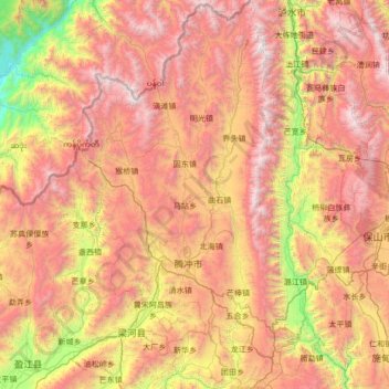
Name: Tengchong City topographic map, elevation, terrain.
Location: Tengchong City, Baoshan, Yunnan, 679100, China (24.62636 98.08895 25.85988 98.77383)
Average elevation: 1,830 m
Minimum elevation: 174 m
Maximum elevation: 3,717 m
Make a donation
Other topographic maps
Click on a map to view its topography, its elevation and its terrain.