
Thank you for supporting this site ❤️
Make a donation
Make a donation
Alto topographic map
Click on the map to display elevation.
Thank you for supporting this site ❤️
Make a donation
Make a donation
Alto
The town of Alto was laid out in 1849 and named for the Spanish word meaning "high" on account of the site's elevation on a drainage divide between the Neches and Angelina Rivers.
Thank you for supporting this site ❤️
Make a donation
Make a donation
About this map
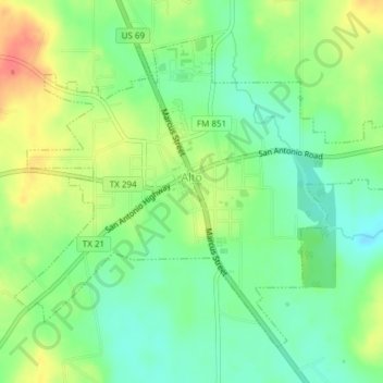
Name: Alto topographic map, elevation, terrain.
Location: Alto, Cherokee County, Texas, United States (31.63611 -95.09026 31.66238 -95.05245)
Average elevation: 130 m
Minimum elevation: 106 m
Maximum elevation: 163 m
Thank you for supporting this site ❤️
Make a donation
Make a donation
Other topographic maps
Click on a map to view its topography, its elevation and its terrain.
Jacksonville
United States > Texas > Cherokee County > Jacksonville > Jacksonville
Average elevation: 154 m
Thank you for supporting this site ❤️
Make a donation
Make a donation