
Make a donation
Meltham topographic map
Click on the map to display elevation.
Make a donation
About this map
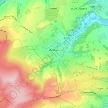
Name: Meltham topographic map, elevation, terrain.
Location: Meltham, Kirklees, West Yorkshire, England, United Kingdom (53.56447 -1.90694 53.61519 -1.81310)
Average elevation: 278 m
Minimum elevation: 106 m
Maximum elevation: 497 m
Make a donation
Other topographic maps
Click on a map to view its topography, its elevation and its terrain.
Make a donation
Make a donation
Make a donation
Make a donation
Slaithwaite
United Kingdom > England > Kirklees
In the 1848 edition of 'A Topographical Dictionary of England', Samuel Lewis (the editor) wrote:- "the lands are in meadow and pasture, with a small portion of arable; the scenery is bold and romantic. In the quarries of the district are found vegetable fossils, especially firs and other mountain trees. The…
Average elevation: 241 m
Make a donation
Make a donation
Make a donation
Make a donation
Make a donation
Make a donation
Make a donation
Make a donation
Make a donation
Make a donation
Make a donation
Make a donation
Make a donation
Make a donation
Make a donation
Make a donation
Clayton West
United Kingdom > England > Kirklees
Listed as Clayton, West, the village featured in "A Topographical Dictionary of England" which was published by Samuel Lewis, London, 1848. In 1848 the village had 1440 residents and was described as being 1080 acres belonging to various owners. Mining was listed as the predominant industry, along with the…
Average elevation: 150 m
Make a donation
Make a donation
Make a donation
Make a donation
Make a donation