
Make a donation
Vița topographic map
Click on the map to display elevation.
Make a donation
About this map
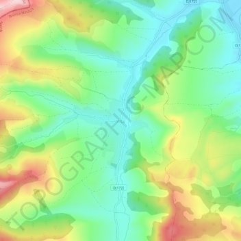
Name: Vița topographic map, elevation, terrain.
Location: Vița, Nușeni, Bistrița-Năsăud, 427207, Romania (47.02147 24.12855 47.06147 24.16855)
Average elevation: 403 m
Minimum elevation: 296 m
Maximum elevation: 588 m
Make a donation
Other topographic maps
Click on a map to view its topography, its elevation and its terrain.
Bistrița
According to Köppen climate classification, Bistrița has a humid continental climate(Dfb) with cold, snowy winters and warm, rainy summers. Due to its modest elevation, Bistrița has one of the coldest climates in Romania.
Average elevation: 429 m
Make a donation
Bistrița
According to Köppen climate classification, Bistrița has a humid continental climate(Dfb) with cold, snowy winters and warm, rainy summers. Due to its modest elevation, Bistrița has one of the coldest climates in Romania.
Average elevation: 429 m
Bistrița
Due to its modest elevation, Bistrița has one of the coldest climates in Romania.
Average elevation: 429 m
Make a donation
Make a donation
Make a donation