
Beni Aziz topographic map
Interactive map
Click on the map to display elevation.
About this map
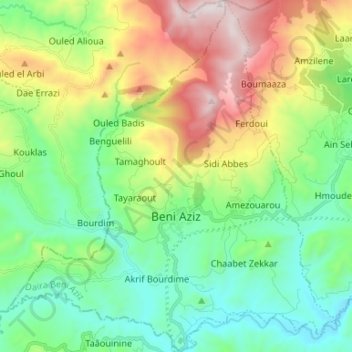
Name: Beni Aziz topographic map, elevation, terrain.
Location: Beni Aziz, Daïra Beni Aziz, Sétif, Algérie (36.42355 5.58594 36.52994 5.71078)
Average elevation: 882 m
Minimum elevation: 501 m
Maximum elevation: 1,676 m
Other topographic maps
Click on a map to view its topography, its elevation and its terrain.
Aïn Sebt
Algérie > Sétif > Daïra Beni Aziz
Aïn Sebt, Daïra Beni Aziz, Sétif, 19033, Algérie
Average elevation: 894 m