
Methil topographic map
Interactive map
Click on the map to display elevation.
About this map
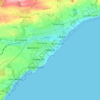
Name: Methil topographic map, elevation, terrain.
Location: Methil, Fife, Scotland, KY8 3HN, United Kingdom (56.14488 -3.05326 56.22488 -2.97326)
Average elevation: 26 m
Minimum elevation: 0 m
Maximum elevation: 155 m
Other topographic maps
Click on a map to view its topography, its elevation and its terrain.
Cowdenbeath
United Kingdom > Scotland > Fife
Cowdenbeath, Fife, Scotland, KY4 9NH, United Kingdom
Average elevation: 130 m
St Andrews
United Kingdom > Scotland > Fife
St Andrews, Fife, Scotland, KY16 9PA, United Kingdom
Average elevation: 38 m
Dunfermline
United Kingdom > Scotland > Fife
Dunfermline, Fife, Scotland, United Kingdom
Average elevation: 114 m
Blebocraigs
United Kingdom > Scotland > Fife > Blebocraigs
Blebocraigs, Fife, Scotland, KY15 5UF, United Kingdom
Average elevation: 86 m