
Thank you for supporting this site ❤️
Make a donation
Make a donation
Le Mont topographic map
Click on the map to display elevation.
Thank you for supporting this site ❤️
Make a donation
Make a donation
About this map
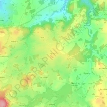
Name: Le Mont topographic map, elevation, terrain.
Average elevation: 368 m
Minimum elevation: 306 m
Maximum elevation: 452 m
Thank you for supporting this site ❤️
Make a donation
Make a donation
Other topographic maps
Click on a map to view its topography, its elevation and its terrain.
Étang de la Grande Cazine
France > Nouvelle-Aquitaine > Creuse > Noth > Beaulieu
Average elevation: 374 m