
Markee topographic map
Interactive map
Click on the map to display elevation.
About this map
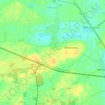
Name: Markee topographic map, elevation, terrain.
Location: Markee, Nauen, Havelland, Brandenburg, Deutschland (52.54112 12.81615 52.59113 12.90578)
Average elevation: 41 m
Minimum elevation: 30 m
Maximum elevation: 52 m
Other topographic maps
Click on a map to view its topography, its elevation and its terrain.
Hertefeld
Deutschland > Brandenburg > Havelland > Nauen
Hertefeld, Bergerdamm, Nauen, Havelland, Brandenburg, 14641, Deutschland
Average elevation: 31 m