
Thank you for supporting this site ❤️
Make a donation
Make a donation
Kundasang topographic map
Click on the map to display elevation.
Thank you for supporting this site ❤️
Make a donation
Make a donation
About this map
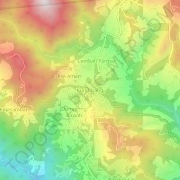
Name: Kundasang topographic map, elevation, terrain.
Location: Kundasang, Sabah, 89308, Malaysia (5.96543 116.55502 6.00543 116.59502)
Average elevation: 1,279 m
Minimum elevation: 856 m
Maximum elevation: 1,739 m
Thank you for supporting this site ❤️
Make a donation
Make a donation