
Thank you for supporting this site ❤️
Make a donation
Make a donation
Engenhos topographic map
Click on the map to display elevation.
Thank you for supporting this site ❤️
Make a donation
Make a donation
About this map
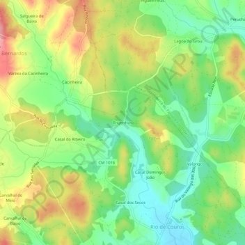
Name: Engenhos topographic map, elevation, terrain.
Location: Engenhos, Rio de Couros, Ourém, Santarém, 2435-530, Portugal (39.72868 -8.52297 39.76868 -8.48297)
Average elevation: 155 m
Minimum elevation: 104 m
Maximum elevation: 223 m
Thank you for supporting this site ❤️
Make a donation
Make a donation