
Apta topographic map
Interactive map
Click on the map to display elevation.
About this map
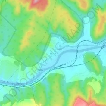
Name: Apta topographic map, elevation, terrain.
Location: Apta, Panvel, Raigad, Maharashtra, 410207, India (18.83407 73.10831 18.87407 73.14831)
Average elevation: 64 m
Minimum elevation: 0 m
Maximum elevation: 216 m
Other topographic maps
Click on a map to view its topography, its elevation and its terrain.
Patalganga
India > Maharashtra > Panvel > Apta
Patalganga, Apta, Panvel, Raigad, Maharashtra, India
Average elevation: 85 m
Mumbai Metropolitan Region
India > Maharashtra > Panvel
Mumbai Metropolitan Region, Panvel, Raigad, Maharashtra, India
Average elevation: 143 m
Patalganga
India > Maharashtra > Panvel
Patalganga, Mumbai Metropolitan Region, Panvel, Raigad, Maharashtra, 410207, India
Average elevation: 13 m
Vahal Village
India > Maharashtra > Panvel
Vahal Village, Panvel, Raigad, Maharashtra, 400614, India
Average elevation: 13 m
Kopra Village
India > Maharashtra > Panvel > Panvel
Kopra Village, Panvel, Raigad, Maharashtra, 400056, India
Average elevation: 13 m