
Make a donation
Pickens County topographic map
Click on the map to display elevation.
Make a donation
Pickens County
Less than one-third of the county was developed for cotton plantations, which were worked by enslaved African-Americans brought south by northern businessmen interested in cheap cotton. These plantations were developed primarily in the southernmost reaches of the county, in the lowlands along the banks of the Tombigbee River and stretching over a small prairie-like area. The rest of the county was settled by yeomen farmers who held few slaves; it was topographically unsuited for plantation-scale farming operations.
Make a donation
About this map
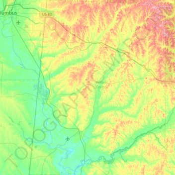
Name: Pickens County topographic map, elevation, terrain.
Location: Pickens County, Alabama, United States (32.99128 -88.34082 33.53397 -87.83630)
Average elevation: 78 m
Minimum elevation: 29 m
Maximum elevation: 181 m
Make a donation
Other topographic maps
Click on a map to view its topography, its elevation and its terrain.
Make a donation
Make a donation
Make a donation
Make a donation
Make a donation
Make a donation
Make a donation
Cheaha Mountain
United States > Alabama > Cleburne County
Cheaha Mountain is part of the Talladega Mountains, a small section of the Ridge and Valley Mountains, unlike other elevations of the Appalachians in north Alabama, which are part of the Cumberland Plateau. The mountain is the highest point in the eastern portion of the Sun Belt (east of the Mississippi River,…
Average elevation: 543 m
Make a donation
Make a donation
Make a donation
Make a donation
Make a donation
Make a donation
Make a donation
Make a donation
Make a donation
Make a donation
Make a donation
Make a donation
Coden
United States > Alabama > Mobile County
Coden is located at 30°22′59″N 88°14′18″W / 30.38306°N 88.23833°W / 30.38306; -88.23833 and has an elevation of 7 feet (2 m).
Average elevation: 3 m
Make a donation
Crestline Heights
United States > Alabama > Jefferson County > Mountain Brook
Average elevation: 241 m
Make a donation
Make a donation
Rickwood Caverns State Park
United States > Alabama > Blount County > Warrior > Reids
Average elevation: 225 m
Make a donation
Make a donation
Make a donation