
Thank you for supporting this site ❤️
Make a donation
Make a donation
Cortes da Veiga topographic map
Click on the map to display elevation.
Thank you for supporting this site ❤️
Make a donation
Make a donation
About this map
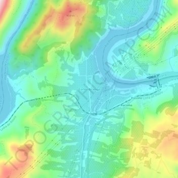
Name: Cortes da Veiga topographic map, elevation, terrain.
Location: Cortes da Veiga, Vila Nova de Foz Côa, Guarda, 5150, Portugal (41.11310 -7.15457 41.15310 -7.11457)
Average elevation: 217 m
Minimum elevation: 102 m
Maximum elevation: 529 m
Thank you for supporting this site ❤️
Make a donation
Make a donation
Other topographic maps
Click on a map to view its topography, its elevation and its terrain.
Thank you for supporting this site ❤️
Make a donation
Make a donation
Thank you for supporting this site ❤️
Make a donation
Make a donation