
Thank you for supporting this site ❤️
Make a donation
Make a donation
Ponte de Frielas topographic map
Click on the map to display elevation.
Thank you for supporting this site ❤️
Make a donation
Make a donation
About this map
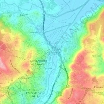
Name: Ponte de Frielas topographic map, elevation, terrain.
Average elevation: 63 m
Minimum elevation: 1 m
Maximum elevation: 176 m
Thank you for supporting this site ❤️
Make a donation
Make a donation
Other topographic maps
Click on a map to view its topography, its elevation and its terrain.
Thank you for supporting this site ❤️
Make a donation
Make a donation
Thank you for supporting this site ❤️
Make a donation
Make a donation
Cabeço de Montachique
Portugal > Lisboa > Loures > Lousa > Cabeço de Montachique
Average elevation: 254 m
Thank you for supporting this site ❤️
Make a donation
Make a donation