
Meemure topographic map
Interactive map
Click on the map to display elevation.
About this map
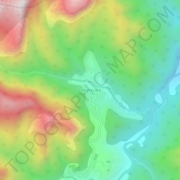
Name: Meemure topographic map, elevation, terrain.
Location: Meemure, Kandy District, Central Province, Sri Lanka (7.42152 80.82421 7.46152 80.86421)
Average elevation: 578 m
Minimum elevation: 210 m
Maximum elevation: 1,179 m
Other topographic maps
Click on a map to view its topography, its elevation and its terrain.
Kandy
Sri Lanka > Central Province > Kandy
Kandy, Kandy District, Central Province, 20000, Sri Lanka
Average elevation: 621 m
Nattarampota
Sri Lanka > Central Province > Nattarampota
Nattarampota, Kandy District, Central Province, 60622, Sri Lanka
Average elevation: 498 m