
Laussac topographic map
Interactive map
Click on the map to display elevation.
About this map
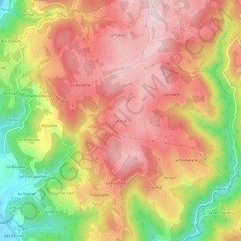
Name: Laussac topographic map, elevation, terrain.
Average elevation: 368 m
Minimum elevation: 145 m
Maximum elevation: 518 m
Other topographic maps
Click on a map to view its topography, its elevation and its terrain.
Le Rieux
France > Nouvelle-Aquitaine > Corrèze > Altillac
Le Rieux, Altillac, Brive-la-Gaillarde, Corrèze, Nouvelle-Aquitaine, France métropolitaine, 19120, France
Average elevation: 275 m
Ciran
France > Nouvelle-Aquitaine > Corrèze > Altillac
Ciran, Altillac, Brive-la-Gaillarde, Corrèze, Nouvelle-Aquitaine, France métropolitaine, 19120, France
Average elevation: 246 m
La Garenne
France > Nouvelle-Aquitaine > Corrèze > Altillac
La Garenne, Altillac, Brive-la-Gaillarde, Corrèze, Nouvelle-Aquitaine, France métropolitaine, 19120, France
Average elevation: 227 m
Le Rodal
France > Nouvelle-Aquitaine > Corrèze > Altillac
Le Rodal, Altillac, Brive-la-Gaillarde, Corrèze, Nouvelle-Aquitaine, France métropolitaine, 19120, France
Average elevation: 251 m