
Thank you for supporting this site ❤️
Make a donation
Make a donation
Little Shurdington topographic map
Click on the map to display elevation.
Thank you for supporting this site ❤️
Make a donation
Make a donation
About this map
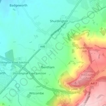
Name: Little Shurdington topographic map, elevation, terrain.
Average elevation: 112 m
Minimum elevation: 36 m
Maximum elevation: 296 m
Thank you for supporting this site ❤️
Make a donation
Make a donation
Other topographic maps
Click on a map to view its topography, its elevation and its terrain.
Crickley Hill and Barrow Wake
United Kingdom > England > Gloucestershire > Tewkesbury > Bentham
Average elevation: 205 m