
Thank you for supporting this site ❤️
Make a donation
Make a donation
Mount Airy Estates topographic map
Click on the map to display elevation.
Thank you for supporting this site ❤️
Make a donation
Make a donation
About this map
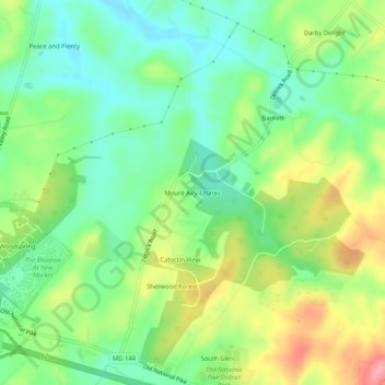
Name: Mount Airy Estates topographic map, elevation, terrain.
Average elevation: 161 m
Minimum elevation: 118 m
Maximum elevation: 229 m
Thank you for supporting this site ❤️
Make a donation
Make a donation
Other topographic maps
Click on a map to view its topography, its elevation and its terrain.
Monocacy River
United States > Maryland > Frederick County > Bartonsville > Pine Cliff
Average elevation: 97 m
Thank you for supporting this site ❤️
Make a donation
Make a donation
Thank you for supporting this site ❤️
Make a donation
Make a donation