
Thank you for supporting this site ❤️
Make a donation
Make a donation
Castle Dale topographic map
Click on the map to display elevation.
Thank you for supporting this site ❤️
Make a donation
Make a donation
About this map
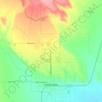
Name: Castle Dale topographic map, elevation, terrain.
Location: Castle Dale, Emery County, Utah, 84513, United States (39.20557 -111.04270 39.24431 -111.00308)
Average elevation: 1,758 m
Minimum elevation: 1,703 m
Maximum elevation: 1,830 m
Thank you for supporting this site ❤️
Make a donation
Make a donation
Other topographic maps
Click on a map to view its topography, its elevation and its terrain.
Thank you for supporting this site ❤️
Make a donation
Make a donation
Castle Dale
United States > Utah > Emery County > Castle Dale > Castle Dale
Average elevation: 1,745 m