
Thank you for supporting this site ❤️
Make a donation
Make a donation
KOLLI HILLS topographic map
Click on the map to display elevation.
Thank you for supporting this site ❤️
Make a donation
Make a donation
About this map
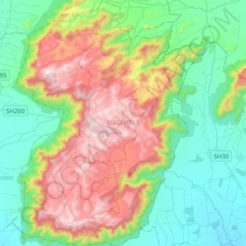
Name: KOLLI HILLS topographic map, elevation, terrain.
Location: KOLLI HILLS, Namakkal District, Tamil Nadu, 637411, India (11.18809 78.27669 11.45428 78.48973)
Average elevation: 563 m
Minimum elevation: 145 m
Maximum elevation: 1,403 m
Thank you for supporting this site ❤️
Make a donation
Make a donation
Other topographic maps
Click on a map to view its topography, its elevation and its terrain.
Auroville
India > Tamil Nadu > Vanur
It is included in the sub-humid tropics (wet-and-dry tropical climate) situated on a plateau region with its maximum elevation of 32 m (105 ft) above sea level located in the Matrimandir area. The annual rainfall average is 1,200 mm (47 in) mainly from the SW monsoon (June to Sept.) and NE monsoon (Nov to Dec)…
Average elevation: 36 m