
Pasig-Potrero River topographic map
Interactive map
Click on the map to display elevation.
About this map
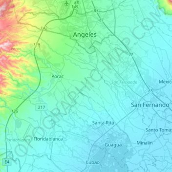
Name: Pasig-Potrero River topographic map, elevation, terrain.
Location: Pasig-Potrero River, Pampanga, Central Luzon, Philippines (14.96709 120.40546 15.14741 120.68517)
Average elevation: 77 m
Minimum elevation: -1 m
Maximum elevation: 673 m
Other topographic maps
Click on a map to view its topography, its elevation and its terrain.
Sapang Maragul
Philippines > Pampanga > Guagua > San Matias
Sapang Maragul, San Matias, Guagua, Pampanga, Central Luzon, Philippines
Average elevation: 5 m
Mount Arayat
Philippines > Pampanga > Arayat
Mount Arayat, Arayat, Pampanga, Central Luzon, Philippines
Average elevation: 639 m
San Ramon
Philippines > Pampanga > Floridablanca
San Ramon, Floridablanca, Pampanga, Central Luzon, Philippines
Average elevation: 107 m
Mawaque
Philippines > Pampanga > Mabalacat
Mawaque, San Francisco, Mabalacat, Pampanga, Central Luzon, 2010, Philippines
Average elevation: 92 m
San Pablo
Philippines > Pampanga > Guagua
San Pablo, Guagua, Pampanga, Central Luzon, 2003, Philippines
Average elevation: 3 m
Macabebe
Macabebe, Pampanga, Central Luzon, 2018, Philippines
Average elevation: 2 m
Telabastagan
Philippines > Pampanga > San Fernando
Telabastagan, San Fernando, Pampanga, Central Luzon, 2000, Philippines
Average elevation: 67 m
Lara
Philippines > Pampanga > San Fernando
Lara, San Fernando, Pampanga, Central Luzon, 1992, Philippines
Average elevation: 56 m
Lakandula
Philippines > Pampanga > Mabalacat
Lakandula, Mabalacat, Pampanga, Central Luzon, 2024, Philippines
Average elevation: 105 m
Pulong Palazan
Philippines > Pampanga > Candaba
Pulong Palazan, Candaba, Pampanga, Central Luzon, 2013, Philippines
Average elevation: 11 m
Purok 7 ( Macamber )
Philippines > Pampanga > Lubao > Santiago
Purok 7 ( Macamber ), Santiago, Lubao, Pampanga, Central Luzon, 2005, Philippines
Average elevation: 12 m
Barangay Dolores Plaza
Philippines > Pampanga > Porac
Barangay Dolores Plaza, Porac, Pampanga, Central Luzon, Philippines
Average elevation: 133 m
Mabalacat
Mabalacat, Pampanga, Central Luzon, 2010, Philippines
Average elevation: 149 m
Balucuc
Philippines > Pampanga > Apalit
Balucuc, Apalit, Pampanga, Central Luzon, Philippines
Average elevation: 8 m
San Fernando
San Fernando, Pampanga, Central Luzon, 2000, Philippines
Average elevation: 15 m
San Pablo Libutad
Philippines > Pampanga > San Simon
San Pablo Libutad, San Simon, Pampanga, Central Luzon, Philippines
Average elevation: 4 m
San Isidro
Philippines > Pampanga > San Fernando
San Isidro, San Fernando, Pampanga, Central Luzon, 2000, Philippines
Average elevation: 22 m
Mexico
Mexico, Pampanga, Central Luzon, 2021, Philippines
Average elevation: 7 m
Rizal
Philippines > Pampanga > Lubao
Rizal, Lubao, Pampanga, Central Luzon, 2003, Philippines
Average elevation: 11 m
Clark
Clark, Mabalacat, Pampanga, Central Luzon, 2023, Philippines
Average elevation: 190 m
Dolores
Philippines > Pampanga > Magalang
Dolores, Magalang, Pampanga, Central Luzon, 2011, Philippines
Average elevation: 41 m
Magalang
Magalang, Pampanga, Central Luzon, 2011, Philippines
Average elevation: 71 m
Purok 3
Philippines > Pampanga > Lubao > San Isidro
Purok 3, San Isidro, Lubao, Pampanga, Central Luzon, 2005, Philippines
Average elevation: 10 m
Purok 1
Philippines > Pampanga > San Fernando > San Juan
Purok 1, San Juan, San Fernando, Pampanga, Central Luzon, 2000, Philippines
Average elevation: 7 m
Paralayunan
Philippines > Pampanga > Mabalacat
Paralayunan, Mabalacat, Pampanga, Central Luzon, 2010, Philippines
Average elevation: 66 m
San Matias
Philippines > Pampanga > Guagua
San Matias, Guagua, Pampanga, Central Luzon, 2003, Philippines
Average elevation: 4 m
Purok 2
Philippines > Pampanga > Magalang
Purok 2, Magalang, Pampanga, Central Luzon, 2011, Philippines
Average elevation: 41 m
Bacolor
Bacolor, Pampanga, Central Luzon, 2001, Philippines
Average elevation: 8 m
Calulut
Philippines > Pampanga > San Fernando
Calulut, San Fernando, Pampanga, Central Luzon, 2015, Philippines
Average elevation: 40 m
Sitio Makabakle
Philippines > Pampanga > San Fernando > Plantation Royale
Sitio Makabakle, Plantation Royale, San Fernando, Pampanga, Central Luzon, 2000, Philippines
Average elevation: 8 m
Guagua
Guagua, Pampanga, Central Luzon, 2003, Philippines
Average elevation: 9 m
Arayat
Arayat, Pampanga, Central Luzon, 2012, Philippines
Average elevation: 40 m
Sacobia River
Philippines > Pampanga > Mabalacat
Sacobia River, Mabalacat, Pampanga, Central Luzon, 2023, Philippines
Average elevation: 167 m
Sasmuan
Sasmuan, Pampanga, Central Luzon, 2004, Philippines
Average elevation: 3 m
San Fernando
San Fernando, Pampanga, Central Luzon, 2000, Philippines
Average elevation: 24 m
Baliti
Baliti, Pampanga, Central Luzon, 1992, Philippines
Average elevation: 55 m
Floridablanca
Floridablanca, Pampanga, Central Luzon, 2006, Philippines
Average elevation: 24 m
Purok 5
Philippines > Pampanga > San Roque > Purok 5
Purok 5, San Roque, Pampanga, Central Luzon, 2006, Philippines
Average elevation: 17 m
Mabalacat
Mabalacat, Pampanga, Central Luzon, Philippines
Average elevation: 117 m
Dau
Philippines > Pampanga > Mabalacat > Dau
Dau, Mabalacat, Pampanga, Central Luzon, 2010, Philippines
Average elevation: 100 m
Eden
Philippines > Pampanga > Eden
Eden, Pampanga, Central Luzon, 2015, Philippines
Average elevation: 40 m
Pampanga River
Pampanga River, Pampanga, Central Luzon, 2017, Philippines
Average elevation: 127 m
Sapang Biabas
Philippines > Pampanga > Mabalacat > Sapang Biabas
Sapang Biabas, Mabalacat, Pampanga, Central Luzon, 2010, Philippines
Average elevation: 84 m
Calumpang
Philippines > Pampanga > Mabalacat > Calumpang
Calumpang, Mabalacat, Pampanga, Central Luzon, 2023, Philippines
Average elevation: 163 m
San Simon
San Simon, Pampanga, Central Luzon, Philippines
Average elevation: 5 m
Sta Monica
Philippines > Pampanga > San Simon > Sta Monica
Sta Monica, San Simon, Pampanga, Central Luzon, 2016, Philippines
Average elevation: 4 m
Bulaon
Philippines > Pampanga > Bulaon
Bulaon, Pampanga, Central Luzon, 2000, Philippines
Average elevation: 28 m