
Thank you for supporting this site ❤️
Make a donation
Make a donation
Blanchard topographic map
Click on the map to display elevation.
Thank you for supporting this site ❤️
Make a donation
Make a donation
About this map
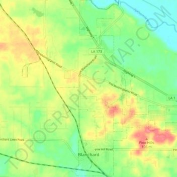
Name: Blanchard topographic map, elevation, terrain.
Location: Blanchard, Caddo Parish, Louisiana, 71009, United States (32.57260 -93.90933 32.64651 -93.82470)
Average elevation: 76 m
Minimum elevation: 45 m
Maximum elevation: 115 m
Thank you for supporting this site ❤️
Make a donation
Make a donation
Other topographic maps
Click on a map to view its topography, its elevation and its terrain.
Thank you for supporting this site ❤️
Make a donation
Make a donation
Thank you for supporting this site ❤️
Make a donation
Make a donation
Cynthia Park
United States > Louisiana > Caddo Parish > Shreveport > Cynthia Park
Average elevation: 71 m