
Thank you for supporting this site ❤️
Make a donation
Make a donation
Sterling topographic map
Click on the map to display elevation.
Thank you for supporting this site ❤️
Make a donation
Make a donation
Sterling
According to the USGS, Sterling has an average elevation of 289 feet (88 m) above sea level. The original center of Sterling is located at 39°00'22.4"N 77°25'43.0"W. Sterling is part of the Chesapeake Bay watershed, and Greater Sterling borders the Potomac River.
Thank you for supporting this site ❤️
Make a donation
Make a donation
About this map
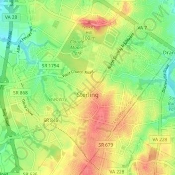
Name: Sterling topographic map, elevation, terrain.
Location: Sterling, Loudoun County, Virginia, 20164, United States (38.98265 -77.43496 39.02504 -77.37132)
Average elevation: 97 m
Minimum elevation: 63 m
Maximum elevation: 131 m
Thank you for supporting this site ❤️
Make a donation
Make a donation