
Make a donation
Posina topographic map
Click on the map to display elevation.
Make a donation
Posina
Posina is a town in the province of Vicenza, Veneto, Italy. It is northeast of SS46. As of 2007 Posina had an estimated population of 657. Posina lies at an elevation of 600 metres (2,000 ft) at the foot of Mount Majo and Mount Gamonda, Mount Pasubio. On the whole dominates the Pasubio which can be accessed through the picturesque Val Caprara, Val Sorapache or arrived at passo Xomo on the Strada degli Scarubbi or the famous Strada delle 52 gallerie great work of military engineering the First World War.
Make a donation
About this map
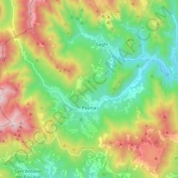
Name: Posina topographic map, elevation, terrain.
Location: Posina, Vicenza, Veneto, 36010, Italy (45.76878 11.18909 45.83300 11.32248)
Average elevation: 996 m
Minimum elevation: 403 m
Maximum elevation: 2,051 m
Make a donation
Other topographic maps
Click on a map to view its topography, its elevation and its terrain.
Monte Cengio
Italy > Veneto > Vicenza > Cogollo del Cengio
Monte Cengio is a mountain in the Asiago plateau, within the Vicentine Alps, in Veneto, northeastern Italy. It has an elevation of 1,354 metres and is located on the southwestern edge of the plateau, in the territory of Cogollo del Cengio.
Average elevation: 935 m
Make a donation
Make a donation
Make a donation
Make a donation
Make a donation