
Make a donation
Traunkirchen topographic map
Click on the map to display elevation.
Make a donation
About this map
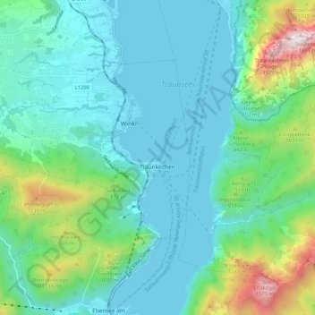
Name: Traunkirchen topographic map, elevation, terrain.
Location: Traunkirchen, Bezirk Gmunden, Upper Austria, 4801, Austria (47.82521 13.69733 47.86846 13.80105)
Average elevation: 669 m
Minimum elevation: 417 m
Maximum elevation: 1,649 m
Make a donation
Other topographic maps
Click on a map to view its topography, its elevation and its terrain.
Hoher Dachstein
Austria > Upper Austria > Bezirk Gmunden > Gosau
The Dachstein massif covers an area of around 600 square kilometres (230 sq mi) with dozens of peaks above 2,500 m, the highest of which are in the southern and southwestern areas. The main summit of the Hoher Dachstein is at an elevation of 2,997 metres (9,833 ft). Seen from the north, the Dachstein massif is…
Average elevation: 2,341 m
Make a donation
Predigstuhl
Austria > Upper Austria > Bezirk Gmunden > Bad Goisern am Hallstättersee
Average elevation: 921 m
Bad Goisern
Austria > Upper Austria > Bezirk Gmunden > Bad Goisern am Hallstättersee > Bad Goisern
Average elevation: 644 m
Make a donation
Make a donation