
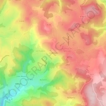
Les Brosses topographic map
Interactive map
Click on the map to display elevation.
About this map
Name: Les Brosses topographic map, elevation, terrain.
Average elevation: 508 m
Minimum elevation: 326 m
Maximum elevation: 625 m
Other topographic maps
Click on a map to view its topography, its elevation and its terrain.
Savault
France > Bourgogne-Franche-Comté > Nièvre > Ouroux-en-Morvan
Savault, Ouroux-en-Morvan, Château-Chinon (Ville), Nièvre, Bourgogne-Franche-Comté, France métropolitaine, 58230, France
Average elevation: 514 m
Savelot
France > Bourgogne-Franche-Comté > Nièvre > Ouroux-en-Morvan > Savelot
Savelot, Ouroux-en-Morvan, Château-Chinon (Ville), Nièvre, Bourgogne-Franche-Comté, France métropolitaine, 58230, France
Average elevation: 555 m
Coeuzon
France > Bourgogne-Franche-Comté > Nièvre > Ouroux-en-Morvan
Coeuzon, Ouroux-en-Morvan, Château-Chinon (Ville), Nièvre, Bourgogne-Franche-Comté, France métropolitaine, 58230, France
Average elevation: 564 m
Le Plessis
France > Bourgogne-Franche-Comté > Nièvre > Ouroux-en-Morvan > Le Plessis
Le Plessis, Ouroux-en-Morvan, Château-Chinon (Ville), Nièvre, Bourgogne-Franche-Comté, France métropolitaine, 58230, France
Average elevation: 539 m
Jallois
France > Bourgogne-Franche-Comté > Nièvre > Ouroux-en-Morvan
Jallois, Ouroux-en-Morvan, Château-Chinon (Ville), Nièvre, Bourgogne-Franche-Comté, France métropolitaine, 58230, France
Average elevation: 517 m