
Thank you for supporting this site ❤️
Make a donation
Make a donation
Lake Mooney topographic map
Click on the map to display elevation.
Thank you for supporting this site ❤️
Make a donation
Make a donation
About this map
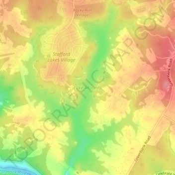
Name: Lake Mooney topographic map, elevation, terrain.
Location: Lake Mooney, Stafford County, Virginia, United States (38.33420 -77.56050 38.36299 -77.53582)
Average elevation: 76 m
Minimum elevation: 23 m
Maximum elevation: 108 m
Thank you for supporting this site ❤️
Make a donation
Make a donation
Other topographic maps
Click on a map to view its topography, its elevation and its terrain.