
Kirchweyhe topographic map
Interactive map
Click on the map to display elevation.
About this map
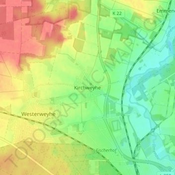
Name: Kirchweyhe topographic map, elevation, terrain.
Location: Kirchweyhe, Uelzen, Niedersachsen, 29579, Deutschland (52.98321 10.51398 53.02321 10.55398)
Average elevation: 58 m
Minimum elevation: 26 m
Maximum elevation: 95 m
Other topographic maps
Click on a map to view its topography, its elevation and its terrain.
Hambrock
Deutschland > Niedersachsen > Uelzen > Uelzen > Hambrock
Hambrock, Uelzen, Niedersachsen, 29525, Deutschland
Average elevation: 49 m