
Thank you for supporting this site ❤️
Make a donation
Make a donation
Faistenau topographic map
Click on the map to display elevation.
Thank you for supporting this site ❤️
Make a donation
Make a donation
About this map
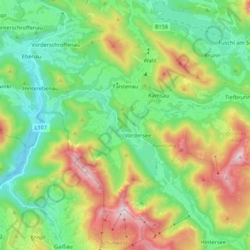
Name: Faistenau topographic map, elevation, terrain.
Location: Faistenau, Bezirk Salzburg-Umgebung, Salzburg, 5324, Austria (47.72527 13.19471 47.79861 13.34953)
Average elevation: 875 m
Minimum elevation: 549 m
Maximum elevation: 1,539 m
Thank you for supporting this site ❤️
Make a donation
Make a donation
Other topographic maps
Click on a map to view its topography, its elevation and its terrain.
Wallersee
Austria > Salzburg > Bezirk Salzburg-Umgebung > Seekirchen am Wallersee > Fischtaging
Average elevation: 531 m
Thank you for supporting this site ❤️
Make a donation
Make a donation
Thank you for supporting this site ❤️
Make a donation
Make a donation
Thank you for supporting this site ❤️
Make a donation
Make a donation