
Kadmat topographic map
Interactive map
Click on the map to display elevation.
About this map
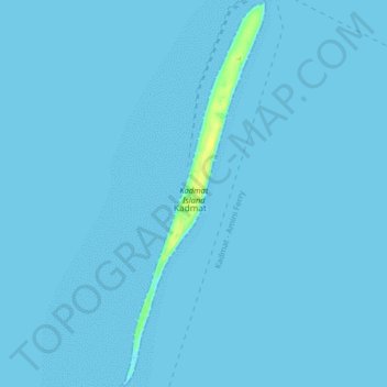
Name: Kadmat topographic map, elevation, terrain.
Location: Kadmat, Lakshadweep, India (11.17989 72.75982 11.25910 72.79013)
Average elevation: 0 m
Minimum elevation: 0 m
Maximum elevation: 15 m
Other topographic maps
Click on a map to view its topography, its elevation and its terrain.
Minicoy Island
India > Lakshadweep > Minicoy > Minicoy
Minicoy Island, Minicoy, Lakshadweep, 682559, India
Average elevation: 1 m
Kavaratti Island
India > Lakshadweep > Kavaratti > Kavaratti
Kavaratti Island, Kavaratti, Lakshadweep, 262240, India
Average elevation: 2 m
Kadmat Island
India > Lakshadweep > Kadmat > Kadmat
Kadmat Island, Kadmat, Lakshadweep, India
Average elevation: 0 m
Bangaram Island
India > Lakshadweep > Agatti
Bangaram Island, Agatti, Lakshadweep, India
Average elevation: 0 m
Kalpeni Island
India > Lakshadweep > Kalpeni > Kalpeni
Kalpeni Island, Kalpeni, Lakshadweep, India
Average elevation: 1 m