Roxbury topographic map
Interactive map
Click on the map to display elevation.
About this map
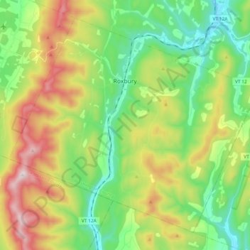
Name: Roxbury topographic map, elevation, terrain.
Location: Roxbury, Washington County, Vermont, 05669, United States (44.01281 -72.81894 44.12670 -72.63448)
Average elevation: 494 m
Minimum elevation: 226 m
Maximum elevation: 969 m
More than twenty points within the town have an elevation of more than 2,000 feet (610 m); elevations in the town range from a low of 880 feet (270 m) (along the Third Branch of the White River) to a high of 3,086 feet (941 m) (at the peak of Rice Mountain). Rice Mountain lies in the Northfield range of the Green Mountains along the western boundary of the town.
Other topographic maps
Click on a map to view its topography, its elevation and its terrain.
Montpelier
United States > Vermont > Washington County
Montpelier, Washington County, Vermont, 05602, United States
Average elevation: 284 m
Worcester
United States > Vermont > Washington County
Worcester, Washington County, Vermont, 05682, United States
Average elevation: 461 m
Duxbury
United States > Vermont > Washington County
Duxbury, Washington County, Vermont, 05676, United States
Average elevation: 335 m
Middlesex
United States > Vermont > Washington County
Middlesex, Washington County, Vermont, United States
Average elevation: 331 m
Woodbury
United States > Vermont > Washington County
Woodbury, Washington County, Vermont, 05681, United States
Average elevation: 411 m
Adamant
United States > Vermont > Washington County > Calais
Adamant, Calais, Washington County, Vermont, 05640, United States
Average elevation: 365 m
East Montpelier
United States > Vermont > Washington County
East Montpelier, Washington County, Vermont, United States
Average elevation: 311 m
Marshfield
United States > Vermont > Washington County
Marshfield, Washington County, Vermont, 05658, United States
Average elevation: 403 m
Cabot
United States > Vermont > Washington County
Cabot, Washington County, Vermont, 05647, United States
Average elevation: 458 m
Mount Ellen
United States > Vermont > Washington County > Warren
Mount Ellen, Warren, Washington County, Vermont, United States
Average elevation: 906 m
Barre City
United States > Vermont > Washington County
Barre City, Washington County, Vermont, 05641, United States
Average elevation: 261 m
Sugarbush Village
United States > Vermont > Washington County > Warren
Sugarbush Village, Warren, Washington County, Vermont, United States
Average elevation: 606 m
Waterbury
United States > Vermont > Washington County > Waterbury
Waterbury, Washington County, Vermont, United States
Average elevation: 199 m
East Roxbury
United States > Vermont > Washington County > Roxbury
East Roxbury, Roxbury, Washington County, Vermont, United States
Average elevation: 470 m
North Montpelier
United States > Vermont > Washington County > East Montpelier
North Montpelier, East Montpelier, Washington County, Vermont, 05666, United States
Average elevation: 278 m
Berlin
United States > Vermont > Washington County
Berlin, Washington County, Vermont, United States
Average elevation: 315 m
North Duxbury
United States > Vermont > Washington County > Duxbury
North Duxbury, Duxbury, Washington County, Vermont, United States
Average elevation: 275 m
Moretown
United States > Vermont > Washington County > Moretown
Moretown, Washington County, Vermont, 05660, United States
Average elevation: 383 m
Waitsfield
United States > Vermont > Washington County > Waitsfield
Waitsfield, Washington County, Vermont, 05673, United States
Average elevation: 424 m
Plainfield
United States > Vermont > Washington County
Plainfield, Washington County, Vermont, 05667, United States
Average elevation: 386 m
Northfield
United States > Vermont > Washington County > Northfield
Northfield, Washington County, Vermont, 05663, United States
Average elevation: 298 m
Warren
United States > Vermont > Washington County
Warren, Washington County, Vermont, 05674, United States
Average elevation: 575 m