
Thank you for supporting this site ❤️
Make a donation
Make a donation
Eichenau topographic map
Click on the map to display elevation.
Thank you for supporting this site ❤️
Make a donation
Make a donation
Eichenau
Die Spannungen mit der Muttergemeinde Alling erreichten ihren Höhepunkt 1925, als die mehrheitlich Eichenauer Gemeinderäte die Verlegung der Gemeindeverwaltung nach Eichenau beschlossen.
Thank you for supporting this site ❤️
Make a donation
Make a donation
About this map
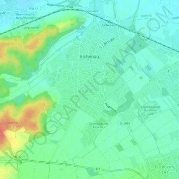
Name: Eichenau topographic map, elevation, terrain.
Average elevation: 530 m
Minimum elevation: 510 m
Maximum elevation: 585 m
Thank you for supporting this site ❤️
Make a donation
Make a donation
Other topographic maps
Click on a map to view its topography, its elevation and its terrain.
Pleitmannswang
Deutschland > Bayern > Landkreis Fürstenfeldbruck > Türkenfeld
Average elevation: 568 m
Thank you for supporting this site ❤️
Make a donation
Make a donation
Weiherhaus
Deutschland > Bayern > Landkreis Fürstenfeldbruck > Fürstenfeldbruck > Gelbenholzen
Average elevation: 543 m
Thank you for supporting this site ❤️
Make a donation
Make a donation
Thank you for supporting this site ❤️
Make a donation
Make a donation