
Make a donation
Gaschurn topographic map
Click on the map to display elevation.
Make a donation
About this map
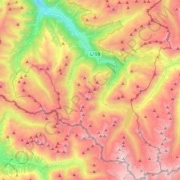
Name: Gaschurn topographic map, elevation, terrain.
Location: Gaschurn, Bezirk Bludenz, Vorarlberg, Austria (46.84086 9.97007 47.03428 10.15998)
Average elevation: 2,101 m
Minimum elevation: 781 m
Maximum elevation: 3,288 m
Make a donation
Other topographic maps
Click on a map to view its topography, its elevation and its terrain.
Zürs
Austria > Vorarlberg > Bezirk Bludenz
Tourism is the main source of income for the town of Zürs. Due to its high altitude (over 2,000m), the landscape is largely free of forest and therefore offers a clear view of the surrounding Alpine peaks. In addition, there is always plenty of snow in the Arlberg region, providing a picturesque setting for…
Average elevation: 2,055 m
Make a donation
Zürs
Austria > Vorarlberg > Bezirk Bludenz
Tourism is the main source of income for the town of Zürs. Due to its high altitude (over 2,000m), the landscape is largely free of forest and therefore offers a clear view of the surrounding Alpine peaks. In addition, there is always plenty of snow in the Arlberg region, providing a picturesque setting for…
Average elevation: 2,055 m
Brandnertal
Austria > Vorarlberg > Bezirk Bludenz > Brand
The Brandnertal is located in the southern part of Vorarlberg, in the far west of Austria. Adjacent to Switzerland, the Principality of Liechtenstein and Germany. In the immediate vicinity of the city of Bludenz starts the Brandnertal. From Bürs the valley rises, via Bürserberg to Brand, which is at an…
Average elevation: 1,572 m
Make a donation
Make a donation
Make a donation