
Belisario Domínguez topographic map
Interactive map
Click on the map to display elevation.
About this map
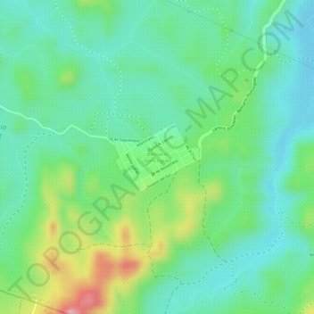
Name: Belisario Domínguez topographic map, elevation, terrain.
Average elevation: 90 m
Minimum elevation: 44 m
Maximum elevation: 185 m
Other topographic maps
Click on a map to view its topography, its elevation and its terrain.
San José de las Lajas
San José de las Lajas, Papantla, Veracruz, Mexico
Average elevation: 135 m
El Aguacate
Mexico > Veracruz > Papantla > El Aguacate
El Aguacate, Terrenos del Lote 18 "La Concha, Aguacate y Totomoxtle", Papantla, Veracruz, Mexico
Average elevation: 92 m