
Make a donation
Rio Grande do Sul topographic map
Click on the map to display elevation.
Make a donation
Rio Grande do Sul
There are two highways, BR-290 and BR-472, running near the airport, besides a railroad line about 2,500 meters from the terminal. Located 9 km (6 mi) from the city center, this airport is at an elevation of 78 meters and the average annual temperature is 20C, with a good deal of variation from summer to winter. Located 630 km (391 mi) from the state capital (Porto Alegre), Uruguaiana was founded on May 29, 1746, and has a current population of 126,936. Farming and ranching are the main economic activities of the region, which has 1,509 rural properties.
Make a donation
About this map
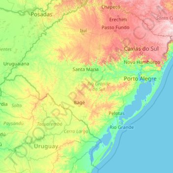
Name: Rio Grande do Sul topographic map, elevation, terrain.
Location: Rio Grande do Sul, South Region, Brazil (-33.86943 -57.64893 -27.08254 -49.49707)
Average elevation: 205 m
Minimum elevation: -4 m
Maximum elevation: 1,636 m
Make a donation
Other topographic maps
Click on a map to view its topography, its elevation and its terrain.
Brasília
Brazil > Federal District > Região Integrada de Desenvolvimento do Distrito Federal e Entorno
The city sits at an elevation of 1,000 metres (3,300 ft) and more, high on the Brazilian Highlands in the country's center-western region. Paranoá Lake, a large artificial lake, was built to increase the amount of water available and to maintain the region's humidity. It has a marina, and hosts wakeboarders…
Average elevation: 1,084 m
Região Metropolitana do Recife
Brazil > Pernambuco > Região Metropolitana do Recife > Cabo de Santo Agostinho
Average elevation: 119 m
Make a donation