
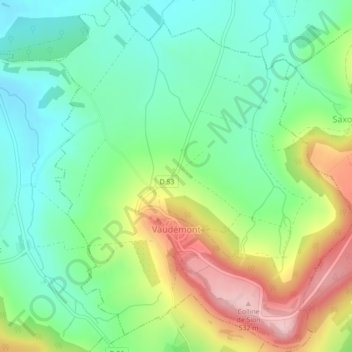
Vaudémont topographic map
Interactive map
Click on the map to display elevation.
About this map
Name: Vaudémont topographic map, elevation, terrain.
Average elevation: 389 m
Minimum elevation: 308 m
Maximum elevation: 537 m
Vaudémont est un village médiéval perché sur un long éperon rocheux nommé « signal de Vaudémont », à une altitude de 480 mètres. Le village est dominé par l'ancien donjon des comtes de Vaudémont. De l'autre côté de cet éperon rocheux se situe la colline de Sion, butte-témoin des côtes de Moselle. À mi-chemin entre Vaudémont et Saxon-Sion se dresse le monument rendant hommage à Maurice Barrès.
Other topographic maps
Click on a map to view its topography, its elevation and its terrain.
Nancy
France > Grand Est > Meurthe-et-Moselle
Nancy, Meurthe-et-Moselle, Grand Est, France métropolitaine, France
Average elevation: 230 m
Chaligny
France > Grand Est > Meurthe-et-Moselle
Chaligny, Nancy, Meurthe-et-Moselle, Grand Est, France métropolitaine, 54230, France
Average elevation: 333 m
Manoncourt-en-Vermois
France > Grand Est > Meurthe-et-Moselle
Manoncourt-en-Vermois, Nancy, Meurthe-et-Moselle, Grand Est, France métropolitaine, 54210, France
Average elevation: 273 m
l'Avrima
France > Grand Est > Meurthe-et-Moselle > Blénod-lès-Pont-à-Mousson
l'Avrima, Blénod-lès-Pont-à-Mousson, Nancy, Meurthe-et-Moselle, Grand Est, France métropolitaine, 54700, France
Average elevation: 203 m
Mercy-le-Haut
France > Grand Est > Meurthe-et-Moselle
Mercy-le-Haut, Val-de-Briey, Meurthe-et-Moselle, Grand Est, France métropolitaine, 54560, France
Average elevation: 337 m
Éply
France > Grand Est > Meurthe-et-Moselle
Éply, Nancy, Meurthe-et-Moselle, Grand Est, France métropolitaine, 54610, France
Average elevation: 209 m
Chambley-Bussières
France > Grand Est > Meurthe-et-Moselle
Chambley-Bussières, Toul, Meurthe-et-Moselle, Grand Est, France métropolitaine, 54890, France
Average elevation: 262 m
Saint-Clément
France > Grand Est > Meurthe-et-Moselle
Saint-Clément, Lunéville, Meurthe-et-Moselle, Grand Est, France métropolitaine, 54950, France
Average elevation: 259 m
Blénod-lès-Pont-à-Mousson
France > Grand Est > Meurthe-et-Moselle
Blénod-lès-Pont-à-Mousson, Nancy, Meurthe-et-Moselle, Grand Est, France métropolitaine, 54700, France
Average elevation: 222 m
Varangéville
France > Grand Est > Meurthe-et-Moselle
Varangéville, Nancy, Meurthe-et-Moselle, Grand Est, France métropolitaine, 54110, France
Average elevation: 240 m
Bénaménil
France > Grand Est > Meurthe-et-Moselle
Bénaménil, Lunéville, Meurthe-et-Moselle, Grand Est, France métropolitaine, 54450, France
Average elevation: 260 m
La Rochotte
France > Grand Est > Meurthe-et-Moselle > Pierre-la-Treiche
La Rochotte, Pierre-la-Treiche, Toul, Meurthe-et-Moselle, Grand Est, France métropolitaine, 54200, France
Average elevation: 241 m
Laneuvelotte
France > Grand Est > Meurthe-et-Moselle
Laneuvelotte, Nancy, Meurthe-et-Moselle, Grand Est, France métropolitaine, 54280, France
Average elevation: 245 m
Custines
France > Grand Est > Meurthe-et-Moselle
Custines, Nancy, Meurthe-et-Moselle, Grand Est, France métropolitaine, 54670, France
Average elevation: 275 m
Damelevières
France > Grand Est > Meurthe-et-Moselle
Damelevières, Lunéville, Meurthe-et-Moselle, Grand Est, France métropolitaine, 54360, France
Average elevation: 231 m
Toul
France > Grand Est > Meurthe-et-Moselle
Toul, Meurthe-et-Moselle, Grand Est, France métropolitaine, 54200, France
Average elevation: 245 m
Gondrecourt-Aix
France > Grand Est > Meurthe-et-Moselle
Gondrecourt-Aix, Val-de-Briey, Meurthe-et-Moselle, Grand Est, France métropolitaine, 54800, France
Average elevation: 258 m
54720
France > Grand Est > Meurthe-et-Moselle > Chenières
54720, Chenières, Val-de-Briey, Meurthe-et-Moselle, Grand Est, France métropolitaine, France
Average elevation: 362 m
Herserange
France > Grand Est > Meurthe-et-Moselle
Herserange, Val-de-Briey, Meurthe-et-Moselle, Grand Est, France métropolitaine, 54440, France
Average elevation: 322 m
Lac de Madine
France > Grand Est > Meurthe-et-Moselle > Pannes
Lac de Madine, Pannes, Toul, Meurthe-et-Moselle, Grand Est, France métropolitaine, 54470, France
Average elevation: 228 m
Sous les Prés la Joue
France > Grand Est > Meurthe-et-Moselle > Villers-la-Montagne
Sous les Prés la Joue, Villers-la-Montagne, Val-de-Briey, Meurthe-et-Moselle, Grand Est, France métropolitaine, 54920, France
Average elevation: 374 m
54400
France > Grand Est > Meurthe-et-Moselle > Cosnes-et-Romain
54400, Cosnes-et-Romain, Val-de-Briey, Meurthe-et-Moselle, Grand Est, France métropolitaine, France
Average elevation: 372 m
Cosnes-et-Romain
France > Grand Est > Meurthe-et-Moselle
Cosnes-et-Romain, Val-de-Briey, Meurthe-et-Moselle, Grand Est, France métropolitaine, 54400, France
Average elevation: 334 m
Maizières
France > Grand Est > Meurthe-et-Moselle
Maizières, Nancy, Meurthe-et-Moselle, Grand Est, France métropolitaine, 54550, France
Average elevation: 288 m
Tellancourt
France > Grand Est > Meurthe-et-Moselle
Tellancourt, Val-de-Briey, Meurthe-et-Moselle, Grand Est, France métropolitaine, 54260, France
Average elevation: 375 m
Ugny
France > Grand Est > Meurthe-et-Moselle
Ugny, Val-de-Briey, Meurthe-et-Moselle, Grand Est, France métropolitaine, 54870, France
Average elevation: 306 m
Saint-Firmin
France > Grand Est > Meurthe-et-Moselle
Saint-Firmin, Nancy, Meurthe-et-Moselle, Grand Est, France métropolitaine, 54930, France
Average elevation: 296 m
Deuxville
France > Grand Est > Meurthe-et-Moselle
Deuxville, Lunéville, Meurthe-et-Moselle, Grand Est, France métropolitaine, 54370, France
Average elevation: 267 m
Cirey-sur-Vezouze
France > Grand Est > Meurthe-et-Moselle
Cirey-sur-Vezouze, Lunéville, Meurthe-et-Moselle, Grand Est, France métropolitaine, 54480, France
Average elevation: 326 m
Allain
France > Grand Est > Meurthe-et-Moselle
Allain, Toul, Meurthe-et-Moselle, Grand Est, France métropolitaine, 54170, France
Average elevation: 312 m
Sexey-aux-Forges
France > Grand Est > Meurthe-et-Moselle
Sexey-aux-Forges, Nancy, Meurthe-et-Moselle, Grand Est, France métropolitaine, 54550, France
Average elevation: 309 m
Écrouves
France > Grand Est > Meurthe-et-Moselle
Écrouves, Toul, Meurthe-et-Moselle, Grand Est, France métropolitaine, 54200, France
Average elevation: 271 m
Bertrichamps
France > Grand Est > Meurthe-et-Moselle
Bertrichamps, Lunéville, Meurthe-et-Moselle, Grand Est, France métropolitaine, 54120, France
Average elevation: 322 m
Houdemont
France > Grand Est > Meurthe-et-Moselle
Houdemont, Nancy, Meurthe-et-Moselle, Grand Est, France métropolitaine, 54180, France
Average elevation: 304 m
Vitrimont
France > Grand Est > Meurthe-et-Moselle
Vitrimont, Lunéville, Meurthe-et-Moselle, Grand Est, France métropolitaine, 54300, France
Average elevation: 265 m
Mexy
France > Grand Est > Meurthe-et-Moselle
Mexy, Val-de-Briey, Meurthe-et-Moselle, Grand Est, France métropolitaine, 54135, France
Average elevation: 341 m
Sexey-les-Bois
France > Grand Est > Meurthe-et-Moselle > Bois-de-Haye
Sexey-les-Bois, Bois-de-Haye, Toul, Meurthe-et-Moselle, Grand Est, France métropolitaine, 54840, France
Average elevation: 260 m
Sainte-Geneviève
France > Grand Est > Meurthe-et-Moselle
Sainte-Geneviève, Nancy, Meurthe-et-Moselle, Grand Est, France métropolitaine, 54700, France
Average elevation: 248 m
Bouxières-sous-Froidmont
France > Grand Est > Meurthe-et-Moselle
Bouxières-sous-Froidmont, Nancy, Meurthe-et-Moselle, Grand Est, France métropolitaine, 54700, France
Average elevation: 253 m
Vandœuvre-lès-Nancy
France > Grand Est > Meurthe-et-Moselle
Vandœuvre-lès-Nancy, Nancy, Meurthe-et-Moselle, Grand Est, France métropolitaine, 54500, France
Average elevation: 273 m
Pont-Saint-Vincent
France > Grand Est > Meurthe-et-Moselle
Pont-Saint-Vincent, Nancy, Meurthe-et-Moselle, Grand Est, France métropolitaine, 54550, France
Average elevation: 289 m
Joudreville
France > Grand Est > Meurthe-et-Moselle
Joudreville, Val-de-Briey, Meurthe-et-Moselle, Grand Est, France métropolitaine, 54490, France
Average elevation: 277 m
Sur la Route de Malleroy
France > Grand Est > Meurthe-et-Moselle > Custines
Sur la Route de Malleroy, Custines, Nancy, Meurthe-et-Moselle, Grand Est, France métropolitaine, 54670, France
Average elevation: 252 m
Aboncourt
France > Grand Est > Meurthe-et-Moselle
Aboncourt, Toul, Meurthe-et-Moselle, Grand Est, France métropolitaine, 54115, France
Average elevation: 373 m
Jœuf
France > Grand Est > Meurthe-et-Moselle
Jœuf, Val-de-Briey, Meurthe-et-Moselle, Grand Est, France métropolitaine, 54240, France
Average elevation: 225 m
Ochey
France > Grand Est > Meurthe-et-Moselle
Ochey, Toul, Meurthe-et-Moselle, Grand Est, France métropolitaine, 54170, France
Average elevation: 288 m
54115
France > Grand Est > Meurthe-et-Moselle > Vandeléville
54115, Vandeléville, Toul, Meurthe-et-Moselle, Grand Est, France métropolitaine, France
Average elevation: 448 m
Jezainville
France > Grand Est > Meurthe-et-Moselle
Jezainville, Nancy, Meurthe-et-Moselle, Grand Est, France métropolitaine, 54700, France
Average elevation: 239 m
Latour La Vitrée Le Saut du Cerf
France > Grand Est > Meurthe-et-Moselle > Pont-à-Mousson
Latour La Vitrée Le Saut du Cerf, Pont-à-Mousson, Nancy, Meurthe-et-Moselle, Grand Est, France métropolitaine, 54700, France
Average elevation: 216 m
Auboué
France > Grand Est > Meurthe-et-Moselle
Auboué, Val-de-Briey, Meurthe-et-Moselle, Grand Est, France métropolitaine, 54580, France
Average elevation: 220 m