
Bhatrahalli topographic map
Interactive map
Click on the map to display elevation.
About this map
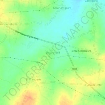
Name: Bhatrahalli topographic map, elevation, terrain.
Location: Bhatrahalli, Kolar taluk, Kolar District, Karnataka, India (13.09128 78.16549 13.13128 78.20549)
Average elevation: 825 m
Minimum elevation: 808 m
Maximum elevation: 844 m
Other topographic maps
Click on a map to view its topography, its elevation and its terrain.
Jangama Basapura
India > Karnataka > Kolar taluk > Bhatrahalli
Jangama Basapura, Bhatrahalli, Kolar taluk, Kolar District, Karnataka, India
Average elevation: 824 m
Kolar
India > Karnataka > Kolar taluk
Kolar, Kolar taluk, Kolar District, Karnataka, 563101, India
Average elevation: 847 m