
Thank you for supporting this site ❤️
Make a donation
Make a donation
Calera topographic map
Click on the map to display elevation.
Thank you for supporting this site ❤️
Make a donation
Make a donation
About this map
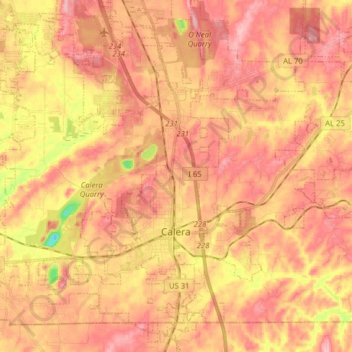
Name: Calera topographic map, elevation, terrain.
Location: Calera, Shelby County, Alabama, 35040, United States (33.05818 -86.81228 33.19018 -86.65568)
Average elevation: 168 m
Minimum elevation: 74 m
Maximum elevation: 218 m
Thank you for supporting this site ❤️
Make a donation
Make a donation
Other topographic maps
Click on a map to view its topography, its elevation and its terrain.
Thank you for supporting this site ❤️
Make a donation
Make a donation
Thank you for supporting this site ❤️
Make a donation
Make a donation