
Thank you for supporting this site ❤️
Make a donation
Make a donation
Vasant Kunj topographic map
Click on the map to display elevation.
Thank you for supporting this site ❤️
Make a donation
Make a donation
About this map
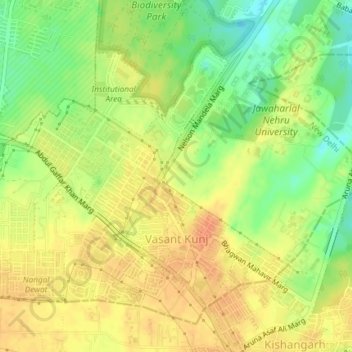
Name: Vasant Kunj topographic map, elevation, terrain.
Location: Vasant Kunj, Vasant Vihar Tehsil, New Delhi, Delhi, India (28.52294 77.12839 28.54683 77.16452)
Average elevation: 262 m
Minimum elevation: 237 m
Maximum elevation: 278 m
Thank you for supporting this site ❤️
Make a donation
Make a donation
Other topographic maps
Click on a map to view its topography, its elevation and its terrain.