
Limpopo topographic map
Interactive map
Click on the map to display elevation.
About this map
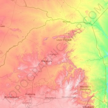
Name: Limpopo topographic map, elevation, terrain.
Location: Limpopo, South Africa (-25.42284 26.40754 -22.12503 31.88439)
Average elevation: 887 m
Minimum elevation: 107 m
Maximum elevation: 2,306 m
Other topographic maps
Click on a map to view its topography, its elevation and its terrain.
Joubertina
South Africa > Eastern Cape > Sarah Baartman District Municipality > Kou-Kamma Local Municipality
Average elevation: 593 m
Heilbron
South Africa > Free State > Fezile Dabi District Municipality > Ngwathe Local Municipality
Average elevation: 1,559 m
Vegkop
South Africa > KwaZulu-Natal > Umzinyathi District Municipality > Endumeni Local Municipality
Average elevation: 1,231 m
Bela-Bela
South Africa > Limpopo > Waterberg District Municipality > Bela Bela Local Municipality
Average elevation: 1,158 m
Devon
South Africa > Gauteng > Sedibeng District Municipality > Lesedi Local Municipality
Average elevation: 1,656 m
Mabule
South Africa > North West > Ngaka Modiri Molema District Municipality > Ratlou Local Municipality
Average elevation: 1,105 m
Kenton-on-Sea
South Africa > Eastern Cape > Sarah Baartman District Municipality > Ndlambe Local Municipality
Average elevation: 22 m
Langebaan
South Africa > Western Cape > West Coast District Municipality > Saldanha Bay Local Municipality
Average elevation: 34 m
Komani
South Africa > Eastern Cape > Chris Hani District Municipality > Lukhanji Local Municipality
Average elevation: 1,149 m
Riebeek-Wes
South Africa > Western Cape > West Coast District Municipality > Swartland Local Municipality
Average elevation: 262 m
Volksrust
South Africa > Mpumalanga > Gert Sibande District Municipality > Pixley Ka Seme Local Municipality > Volksrust
Average elevation: 1,688 m
Majuba
South Africa > KwaZulu-Natal > Amajuba District Municipality > Newcastle Local Municipality
Average elevation: 1,800 m
Vryheid
South Africa > KwaZulu-Natal > Zululand District Municipality > Abaqulusi Local Municipality > Vryheid
Average elevation: 1,191 m
Lusikisiki
South Africa > Eastern Cape > O.R. Tambo District Municipality > Ingquza Hill Local Municipality
Average elevation: 563 m
Pongola
South Africa > KwaZulu-Natal > Zululand District Municipality > uPhongolo Local Municipality > Pongola
Average elevation: 291 m