
Mühlenberge topographic map
Interactive map
Click on the map to display elevation.
About this map
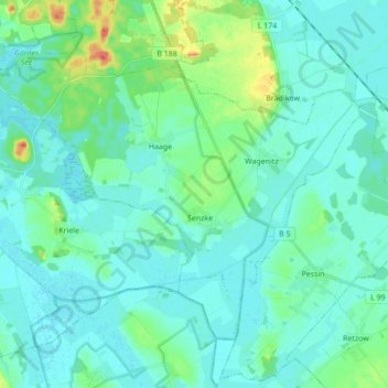
Name: Mühlenberge topographic map, elevation, terrain.
Location: Mühlenberge, Friesack, Havelland, Brandenburg, Deutschland (52.62460 12.51916 52.70341 12.69175)
Average elevation: 35 m
Minimum elevation: 26 m
Maximum elevation: 75 m
Other topographic maps
Click on a map to view its topography, its elevation and its terrain.
Retzow
Deutschland > Brandenburg > Havelland > Friesack
Retzow, Friesack, Havelland, Brandenburg, Deutschland
Average elevation: 36 m
Wiesenaue
Deutschland > Brandenburg > Havelland > Friesack
Wiesenaue, Friesack, Havelland, Brandenburg, Deutschland
Average elevation: 33 m