
Arthenas topographic map
Interactive map
Click on the map to display elevation.
About this map
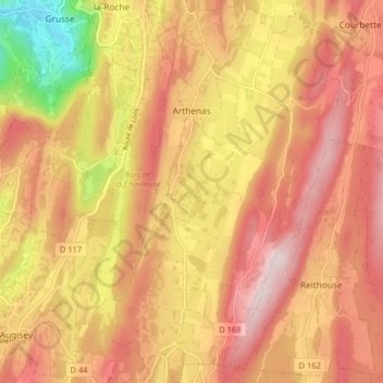
Name: Arthenas topographic map, elevation, terrain.
Average elevation: 500 m
Minimum elevation: 229 m
Maximum elevation: 666 m
Other topographic maps
Click on a map to view its topography, its elevation and its terrain.
Varessia
France > Bourgogne-Franche-Comté > Jura > La Chailleuse
Varessia, La Chailleuse, Lons-le-Saunier, Jura, Bourgogne-Franche-Comté, France métropolitaine, 39270, France
Average elevation: 529 m
Essia
France > Bourgogne-Franche-Comté > Jura > La Chailleuse
Essia, La Chailleuse, Lons-le-Saunier, Jura, Bourgogne-Franche-Comté, France métropolitaine, 39270, France
Average elevation: 527 m