
Thank you for supporting this site ❤️
Make a donation
Make a donation
Bosbeek topographic map
Click on the map to display elevation.
Thank you for supporting this site ❤️
Make a donation
Make a donation
About this map
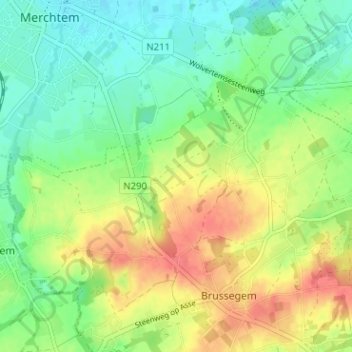
Name: Bosbeek topographic map, elevation, terrain.
Average elevation: 44 m
Minimum elevation: 18 m
Maximum elevation: 81 m
Thank you for supporting this site ❤️
Make a donation
Make a donation
Other topographic maps
Click on a map to view its topography, its elevation and its terrain.
Grote Molenbeek
België > Vlaams-Brabant > Halle-Vilvoorde > Merchtem > Brussegem > Bollebeek
Average elevation: 51 m
Grote Molenbeek
België > Vlaams-Brabant > Halle-Vilvoorde > Merchtem > Brussegem > Steenberg
Average elevation: 47 m