
Make a donation
Zamora Chinchipe topographic map
Click on the map to display elevation.
Make a donation
Zamora Chinchipe
Zamora Chinchipe (Spanish pronunciation: [saˈmoɾa tʃinˈtʃipe]), Province of Zamora Chinchipe is a province of the Republic of Ecuador, located at the southeastern end of the Amazon Basin, which shares borders with the Ecuadorian provinces of Azuay and Morona Santiago to the north, Loja and Azuay to the west, and with Peru to the east and south. The province comprises an area of approximately 10,559 km² and is covered with a uniquely mountainous topography which markedly distinguishes it from the surrounding Amazonian provinces. Zamora-Chinchipe is characterized and largely identified by its mining industry; indigenous ethnic groups with a rich archaeological legacy; its biodiversity; and its niche and tourist attractions, which include a number of waterfalls well-noted for their beauty. The province takes its name from the bureaucratic fusion of the Zamora and Chinchipe cantons. The provincial capital is the city of Zamora.
Make a donation
About this map
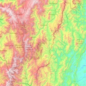
Name: Zamora Chinchipe topographic map, elevation, terrain.
Location: Zamora Chinchipe, Ecuador (-5.01593 -79.43060 -3.34187 -78.36765)
Average elevation: 1,548 m
Minimum elevation: 189 m
Maximum elevation: 3,911 m
Make a donation