
Make a donation
Ilam Province topographic map
Click on the map to display elevation.
Make a donation
Ilam Province
Contrary to the north, the south and southwestern part of the province is covered with low-lying plains with elevation varying between 50 and 300 m (160 and 980 ft) above sea level. Despite receiving little precipitation, large areas of these low lands, notably Dehloran, Musian and Dasht Abbas, are cultivated owing to a combination of factors such as rivers flowing from the mountains to the east, dams and irrigation networks.
Make a donation
About this map
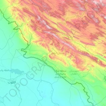
Name: Ilam Province topographic map, elevation, terrain.
Location: Ilam Province, Iran (32.04852 45.69252 34.03770 48.03564)
Average elevation: 630 m
Minimum elevation: 4 m
Maximum elevation: 2,803 m
Make a donation
Other topographic maps
Click on a map to view its topography, its elevation and its terrain.
Baba Jan, East Azerbaijan
Iran > East Azerbaijan Province > Ahar County > دهستان قشلاق
Average elevation: 1,752 m
Make a donation
Shoushtar
Iran > Khuzestan Province > Shushtar County > دهستان سردارآباد > Shoushtar
Average elevation: 75 m
Esfidan
Iran > North Khorasan Province > Bojnurd County > دهستان گرمخان > Esfidan
Average elevation: 1,743 m