
Δήμος Μαραθώνος topographic map
Interactive map
Click on the map to display elevation.
About this map
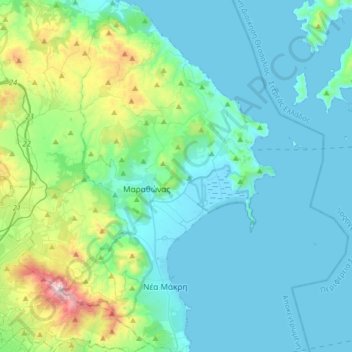
Name: Δήμος Μαραθώνος topographic map, elevation, terrain.
Average elevation: 176 m
Minimum elevation: -1 m
Maximum elevation: 1,095 m
Other topographic maps
Click on a map to view its topography, its elevation and its terrain.
Λαύριο
Griechenland > Attika > Regionalbezirk Ostattika
Λαύριο, Δήμος Λαυρεωτικής, Regionalbezirk Ostattika, Region Attika, Attika, 195 00, Griechenland
Average elevation: 55 m