
Red Oak topographic map
Interactive map
Click on the map to display elevation.
About this map
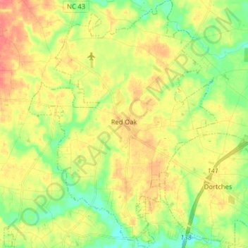
Name: Red Oak topographic map, elevation, terrain.
Location: Red Oak, Nash County, North Carolina, 27868, United States (35.98567 -77.95589 36.08952 -77.85763)
Average elevation: 55 m
Minimum elevation: 28 m
Maximum elevation: 82 m
Other topographic maps
Click on a map to view its topography, its elevation and its terrain.
Dortches
United States > North Carolina > Nash County
Dortches, Nash County, North Carolina, United States
Average elevation: 51 m
Woodridge
United States > North Carolina > Nash County > Rocky Mount
Woodridge, Rocky Mount, Nash County, North Carolina, 27804, United States
Average elevation: 43 m
Spring Hope
United States > North Carolina > Nash County
Spring Hope, Nash County, North Carolina, United States
Average elevation: 80 m
Nashville
United States > North Carolina > Nash County > Nashville
Nashville, Nash County, North Carolina, 27856, United States
Average elevation: 54 m
Little Easonburg
United States > North Carolina > Nash County > Rocky Mount > Little Easonburg
Little Easonburg, Rocky Mount, Nash County, North Carolina, 27804, United States
Average elevation: 48 m
Nashville
United States > North Carolina > Nash County
Nashville, Nash County, North Carolina, United States
Average elevation: 55 m